
Land at Beccles Road, Loddon
Welcome to this public consultation relating to a proposed residential development at land east of Beccles Road and Norton Road, Loddon.
We are pleased to invite you to view the latest proposals for residential development on land to the east of Beccles Road and Norton Road, Loddon, Norfolk, on behalf of the developers Hopkins Homes.
This consultation is now closed.
We are not seeking any further comments. Any additional comments submitted may not be considered.
If you require any further information, you can contact us by email or post at:
Residential Development Proposals at Beccles Road, Loddon, c/o Lanpro Services, Brettingham House, 98 Pottergate, Norwich, NR2 1EQ
The land that Hopkins Homes are considering for development has been identified in the Draft Greater Norwich Local Plan (GNLP). Hopkins Homes have been working with their consultant team to develop a residential development scheme at the site that responds positively to local environmental, historical, and social constraints and opportunities.
The land has been promoted through the GNLP and pre-application engagement has been undertaken with South Norfolk District Council, Norfolk County Council (Highways and Drainage), Loddon Parish Council, and other consulting bodies, to seek their views on key planning and design parameters. This has allowed Hopkins to proactively respond to feedback from this process, to enable the draft proposals to be consulted upon with the local community.
Hopkins are proposing to submit a planning application for the development of the site in due course and wish to hear the views of the local community on the latest proposals before plans our finalised.
This web consultation has been designed to provide you with information on the proposals and to request your feedback.
Hopkins Homes is an established and well-respected house builder with its roots based in East Anglia. The Company has grown significantly over the years to become the largest independent property developer in East Anglia. It takes great pride in the significant contribution that it has made to placemaking and the creation of sustainable communities, as well as contributing to local and regional economies through creating and supporting jobs.
Hopkins Homes are renowned for building new homes with character and individual style and have an enviable track record in terms of delivery. They take an open-minded approach to each individual project and as a result, deliver high quality and consistently popular developments that respect local scale, vernacular and character. The Company approach is to work closely with local communities, local authorities, architects and designers to provide tailor-made developments that respect their setting.
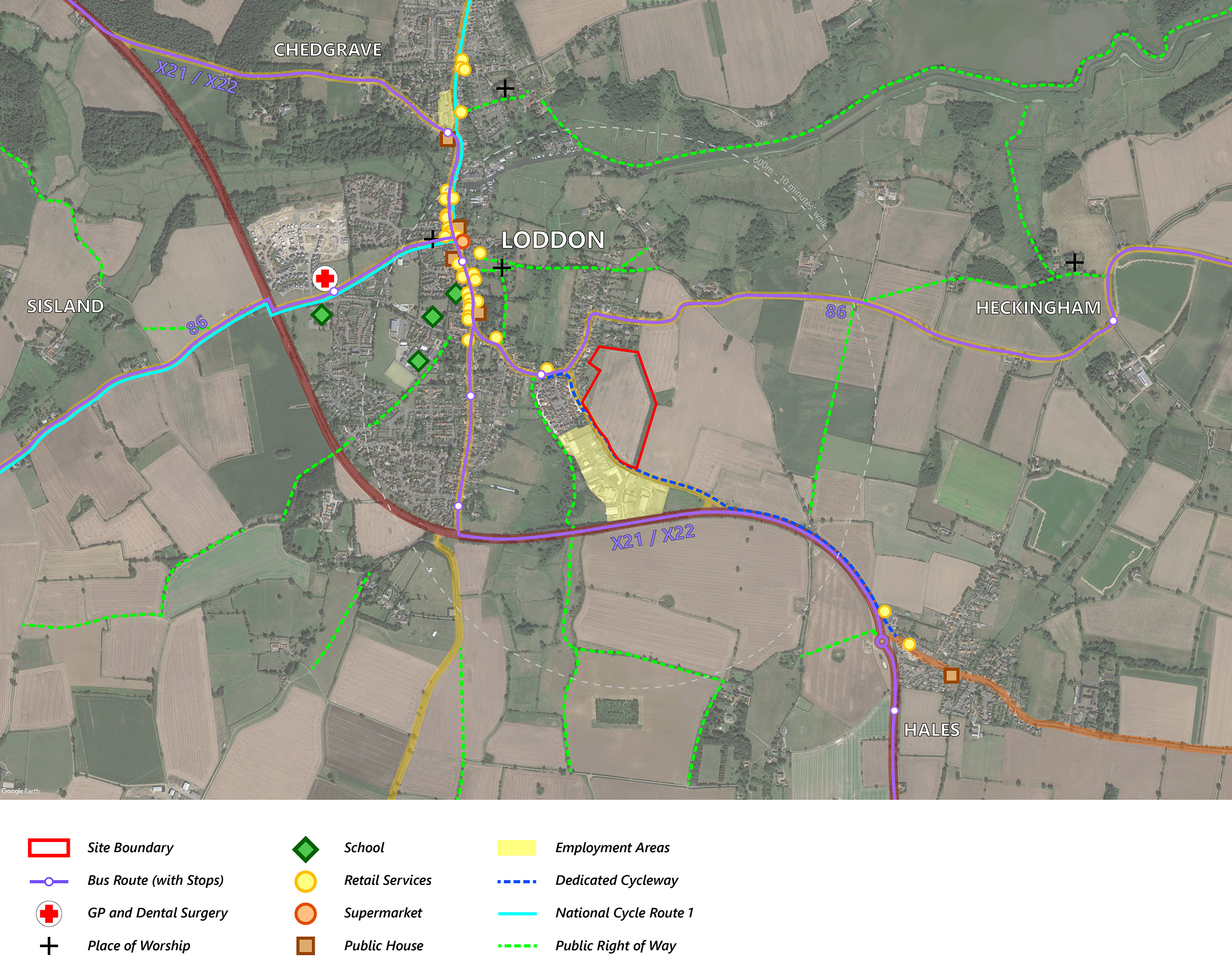
The site is located to the southeast of Loddon, and is approximately 7.6 hectares (18.8 acres) in size. The site currently comprises an agricultural field, containing an associated tree belt to the east. The site adjoins the existing built-up area of Loddon.
(Click on the adjoining site context plan to view larger)
The site is bounded to the north and west by residential properties on Norton Road and Beccles Road. Beccles Road itself forms the southwestern boundary of the site, with the Town Farm Drive/Reeds Way residential development on the opposite side of the road, to the southwest. Directly to the south of the site is the Loddon Industrial Estate on Little Money Road. The eastern boundary of the site is defined by a substantial planted tree belt, which is included within the red line of the proposed site.
Agricultural vehicular access to the site is currently from Beccles Road. Beccles Road itself provides direct vehicular access to the A146, allowing easy access on to Beccles and Norwich. The site also benefits from direct access to dedicated pedestrian and cycling infrastructure along Beccles Road, and easy access to the wider footpath network. National Cycle Route 1 also passes through the town centre.
Loddon benefits from a number of important amenities, including a range of pubs, convenience retail stores, restaurants and takeaways, community spaces, a library, schools from nursery to secondary age (4-16 years old), places of worship and variety of small shops and businesses within the town centre. Regular bus services can be accessed from Church Plain and High Bungay Road, providing public transport access to Lowestoft, Beccles and Norwich. Most of these services are within 10-minutes' walk of the site. The Chet Valley Medical and Dental Surgeries are also located within approximately 15-minute walking distance of the site. Larger business providing greater employment opportunities are located at the Loddon Industrial Estate, directly to the south of the site.
With regard to specific characteristics of the site, the following have been noted:
Historic Context
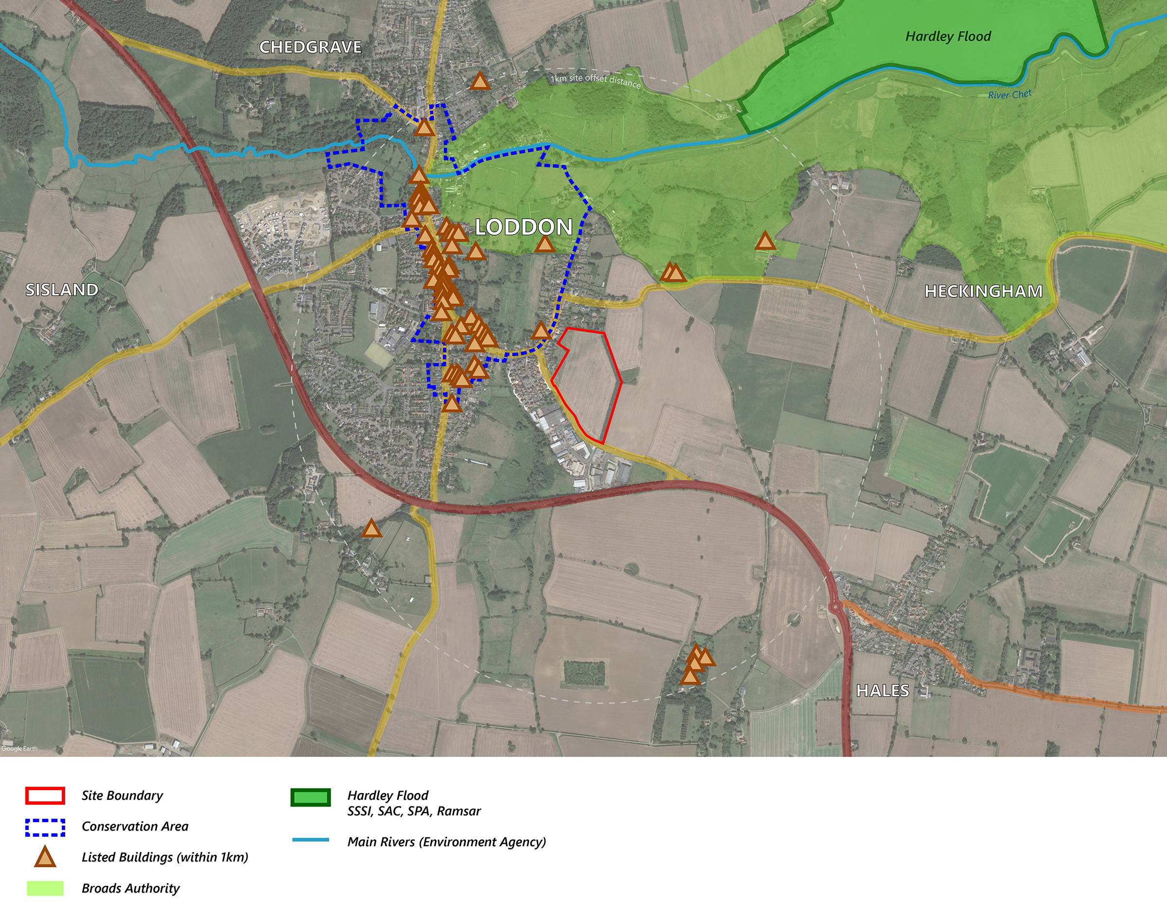
In terms of relevant designated heritage assets, no nationally designated World Heritage Sites, Scheduled Monuments, Historic Battlefield sites or Historic Wreck sites lie within the one-kilometre radius around the site. There are no listed buildings on or immediately adjacent to the site nor is it situated in a Conservation Area, although Loddon Conservation Area, which includes a number of listed buildings (including the Grade I Listed Holy Trinity Church) is located nearby to the northwest of the site. The subject site has remained undeveloped agricultural land throughout the historic periods.
The site occupies a prominent position in the town as a result of its topography, and as such the proposed development seeks to retain the fullest views of the listed building from the east and maintain its function as a local landmark. The eastern part of the site will be retained as open space, with a sightline retained by the layout of the dwellings and road. This will provide an informal “viewing corridor” which will allow the church to still be experienced and appreciated from this part of its wider setting.
Landscape, Ecology and Arboriculture
The site is located within the Chet Tributary Farmland Landscape Character Area, effectively on the urban/rural fringe of the town of Loddon. The site is not covered by any other landscape designations.
The development seeks to demonstrate a well-coordinated landscape and heritage led approach with an imaginative use of green links, maximising the opportunities provided by the topography, and, where possible, incorporating existing landscape features such as hedgerows and trees.
The site is not subject to any ecological designations, however it does fall within the impact risk zone of Hardley Flood, designated SSSI, SAC, SPA and Ramsar, located approximately 1km to the northeast. A desktop search shows no tree preservation orders on or adjacent to the site.
Flooding and Drainage
The site is identified as being at very low risk of flooding from rivers or the sea. The majority of the site is also identified as being at very low risk of flooding from surface water. A small area of high risk is present along Beccles Road on the southern boundary of the site, and this is reflected as a key consideration in the GNLP allocation of the site.
The site is located to the southeast of Loddon, and is approximately 7.6 hectares (18.8 acres) in size. The site currently comprises an agricultural field, containing an associated tree belt to the east. The site adjoins the existing built-up area of Loddon.
(Click on the adjoining site context plan to view larger)
The site is bounded to the north and west by residential properties on Norton Road and Beccles Road. Beccles Road itself forms the southwestern boundary of the site, with the Town Farm Drive/Reeds Way residential development on the opposite side of the road, to the southwest. Directly to the south of the site is the Loddon Industrial Estate on Little Money Road. The eastern boundary of the site is defined by a substantial planted tree belt, which is included within the red line of the proposed site.
Agricultural vehicular access to the site is currently from Beccles Road. Beccles Road itself provides direct vehicular access to the A146, allowing easy access on to Beccles and Norwich. The site also benefits from direct access to dedicated pedestrian and cycling infrastructure along Beccles Road, and easy access to the wider footpath network. National Cycle Route 1 also passes through the town centre.
Loddon benefits from a number of important amenities, including a range of pubs, convenience retail stores, restaurants and takeaways, community spaces, a library, schools from nursery to secondary age (4-16 years old), places of worship and variety of small shops and businesses within the town centre. Regular bus services can be accessed from Church Plain and High Bungay Road, providing public transport access to Lowestoft, Beccles and Norwich. Most of these services are within 10-minutes' walk of the site. The Chet Valley Medical and Dental Surgeries are also located within approximately 15-minute walking distance of the site. Larger business providing greater employment opportunities are located at the Loddon Industrial Estate, directly to the south of the site.
With regard to specific characteristics of the site, the following have been noted:
Historic Context
In terms of relevant designated heritage assets, no nationally designated World Heritage Sites, Scheduled Monuments, Historic Battlefield sites or Historic Wreck sites lie within the one-kilometre radius around the site. There are no listed buildings on or immediately adjacent to the site nor is it situated in a Conservation Area, although Loddon Conservation Area, which includes a number of listed buildings (including the Grade I Listed Holy Trinity Church) is located nearby to the northwest of the site. The subject site has remained undeveloped agricultural land throughout the historic periods.
The site occupies a prominent position in the town as a result of its topography, and as such the proposed development seeks to retain the fullest views of the listed building from the east and maintain its function as a local landmark. The eastern part of the site will be retained as open space, with a sightline retained by the layout of the dwellings and road. This will provide an informal “viewing corridor” which will allow the church to still be experienced and appreciated from this part of its wider setting.
Landscape, Ecology and Arboriculture
The site is located within the Chet Tributary Farmland Landscape Character Area, effectively on the urban/rural fringe of the town of Loddon. The site is not covered by any other landscape designations.
The development seeks to demonstrate a well-coordinated landscape and heritage led approach with an imaginative use of green links, maximising the opportunities provided by the topography, and, where possible, incorporating existing landscape features such as hedgerows and trees.
The site is not subject to any ecological designations, however it does fall within the impact risk zone of Hardley Flood, designated SSSI, SAC, SPA and Ramsar, located approximately 1km to the northeast. A desktop search shows no tree preservation orders on or adjacent to the site.
Flooding and Drainage
The site is identified as being at very low risk of flooding from rivers or the sea. The majority of the site is also identified as being at very low risk of flooding from surface water. A small area of high risk is present along Beccles Road on the southern boundary of the site, and this is reflected as a key consideration in the GNLP allocation of the site.
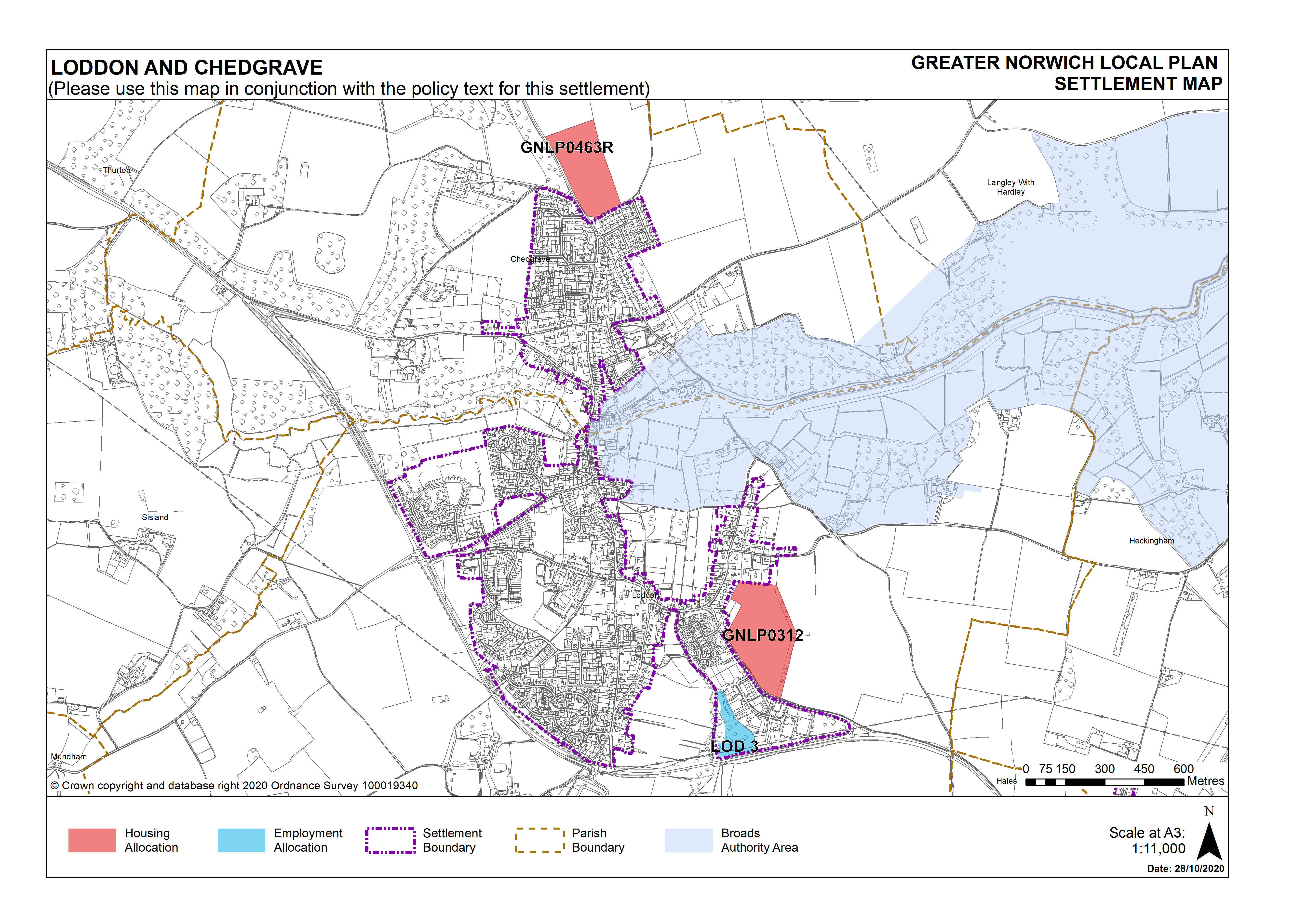
The site is located adjacent to the settlement boundary for Loddon, which is designated as a Key Service Centre in the current Local Plan. Key Service Centres are identified to accommodate growth over the plan period. The current Local Plan is due to be replaced by the GNLP. The GNLP is now at an advanced stage and due to be submitted for examination in Summer-Autumn 2021.
The site at Beccles Road, referenced as GNLP0312, has been identified in the GNLP to be allocated in the emerging plan for 180 dwellings. The site is a preferred allocation for housing development in Loddon and Chedgrave, which as a combined settlement retains its designation as a Key Service Centre in the emerging plan.
As an emerging allocation in the GNLP, the site has been assessed by the relevant planning authorities as suitable for residential development.
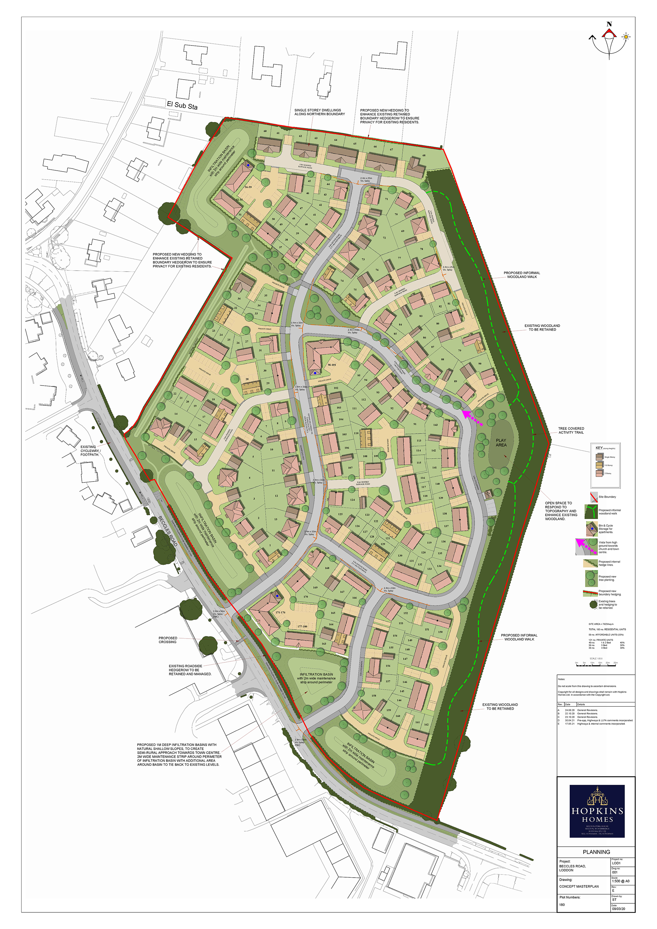
The proposed site layout has gone through several iterations to respond to the constraints, opportunities and sensitivities of the site including, topography, ecology, landscaping, drainage and highways.
(Click on the adjoining site masterplan to enlarge, and navigate between images using the arrows)
The proposed development comprises 180 new homes in a substantial landscape setting. A mixture of 1, 2, 3, and 4 bedroom homes are proposed. Dwellings include bungalows and two-storey housing and apartments, incorporating a variety of complementary design styles to provide choice, visual interest and character whilst maintaining design integrity. Hopkins propose a policy compliant number of affordable homes, comprising a mixture of shared ownership and affordable products, with the remainder for private sale.
The development will be accessed from two newly created access point onto Beccles Road. Existing walking and cycling infrastructure along Beccles Road are to be improved and widened along the site frontage, with a cycleway extending into the site to promote sustainable travel methods into the town centre.
An area of open space has been located on the highest part of the site to provide and take advantage of views of the Holy Trinity Church and across to the town centre, which is a Conservation Area. This will also ensure that rooflines will not break the skyline, thereby enhancing the beneficial effect of the eastern boundary tree belt in creating a green edge to the development.
The topography of the site will help create an interesting gateway to the town. With the site sloping down to Beccles Road, the proposed site layout has been carefully planned to ensure that the surface water drainage strategy will accommodate the surface water runoff without flooding onto Beccles Road. This has been achieved by creating wide open green spaces along the site frontage with proposed 1m deep infiltration basins that have natural shallow slopes. This will create a semi-rural approach towards the town centre.
Existing roadside hedgerows are to be retained and managed. Proposed new hedging is to be added to enhance existing retained boundary hedgerows to ensure privacy for adjacent existing residences.
Attractive and well-designed streets provide a variety of public spaces which are safe and convenient for use by pedestrians, cyclists and vehicles alike. A linear open space has been created to the western boundary with an informal path that links up to the proposed cycleway and streets. Along with the proposed woodland walk the site layout has excellent pedestrian connectivity with strong building frontages along these links to give added surveillance and security.
It is considered that the proposed development will provide a number of benefits, including, amongst others:
- Social benefits through ensuring that there are a sufficient number and range of homes to meet the needs of the local community, the delivery of onsite affordable housing, as well as providing a well-designed and safe environment, with a variety of formal and informal open spaces.
- Environmental benefits, specifically enhancement to the eastern edge of Loddon through the provision of a landscape setting, improvements to biodiversity and ensuring that the new homes are sustainable and energy efficient.
- Promotion of sustainable development through the location of the site within walking and cycling distance of key services and public transport connections.
- Economic benefits, including supporting local amenities and services and creating direct and in-direct employment.
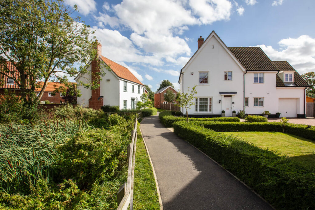
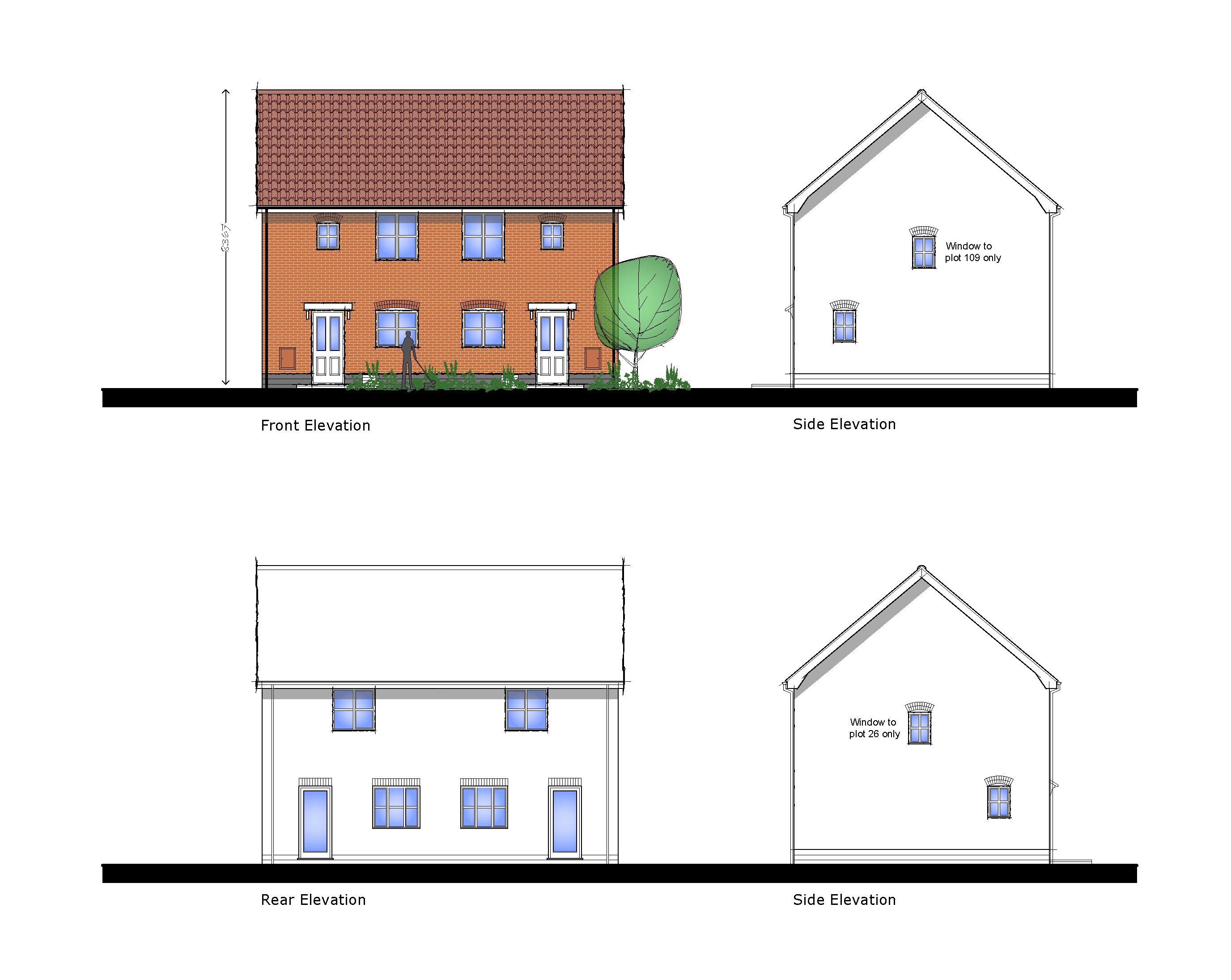
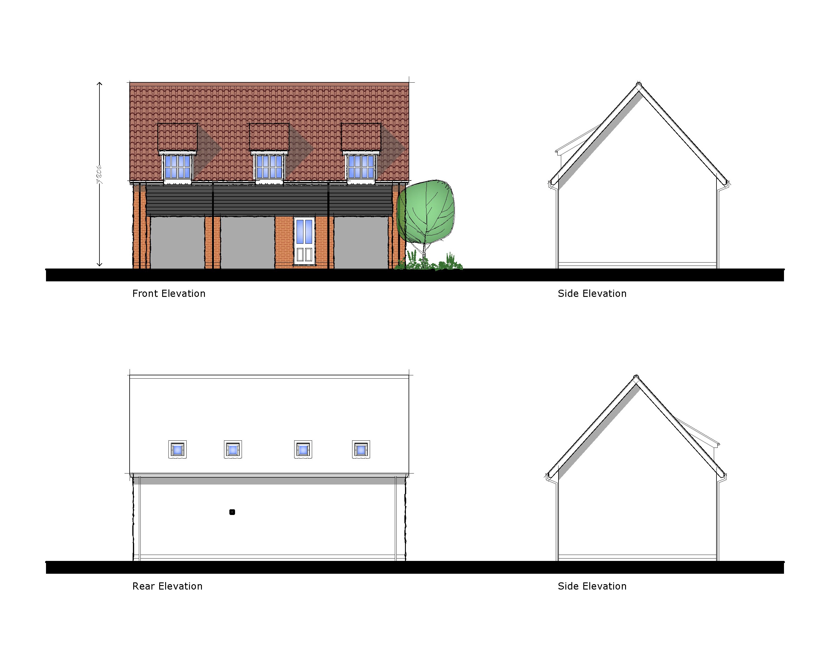
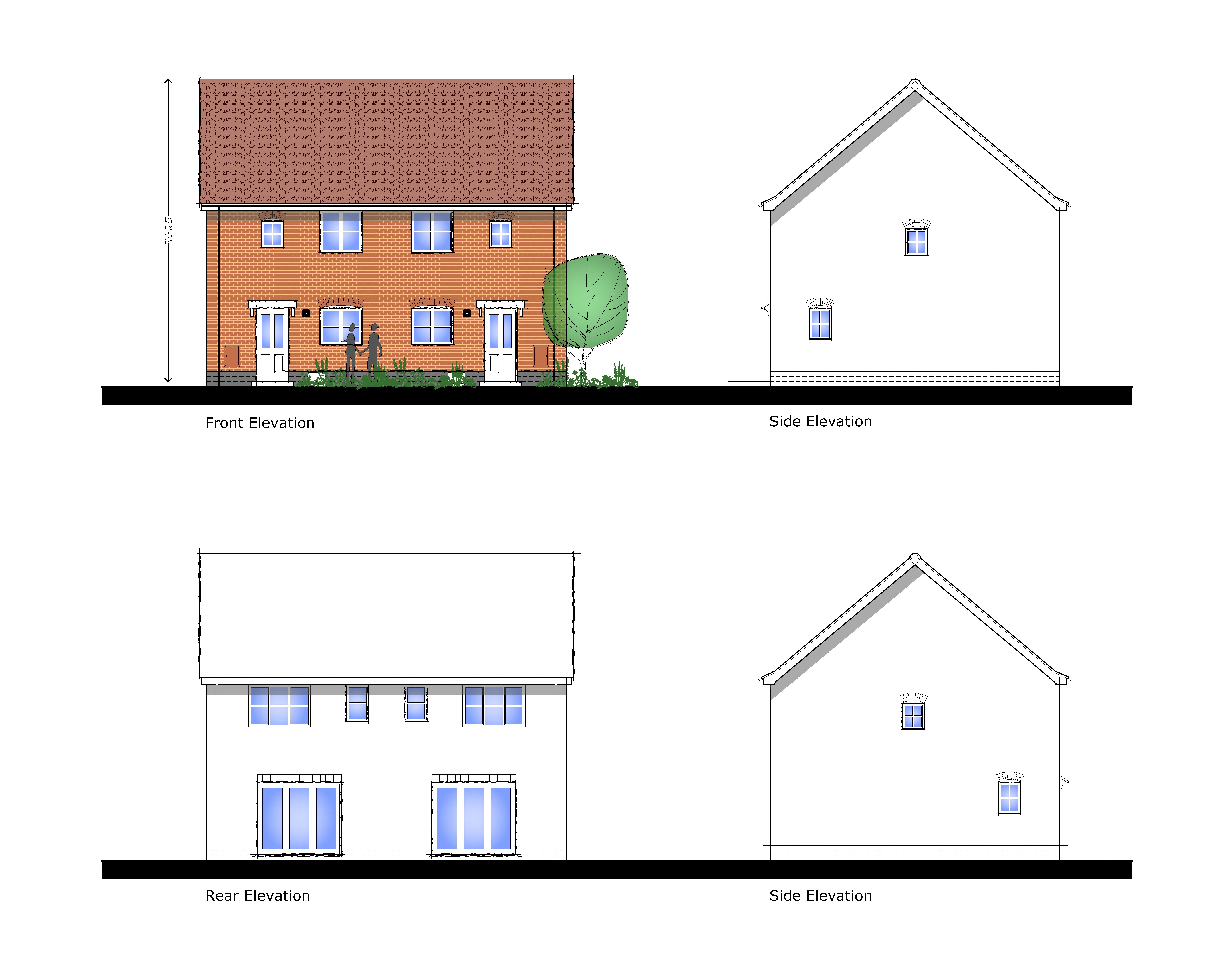
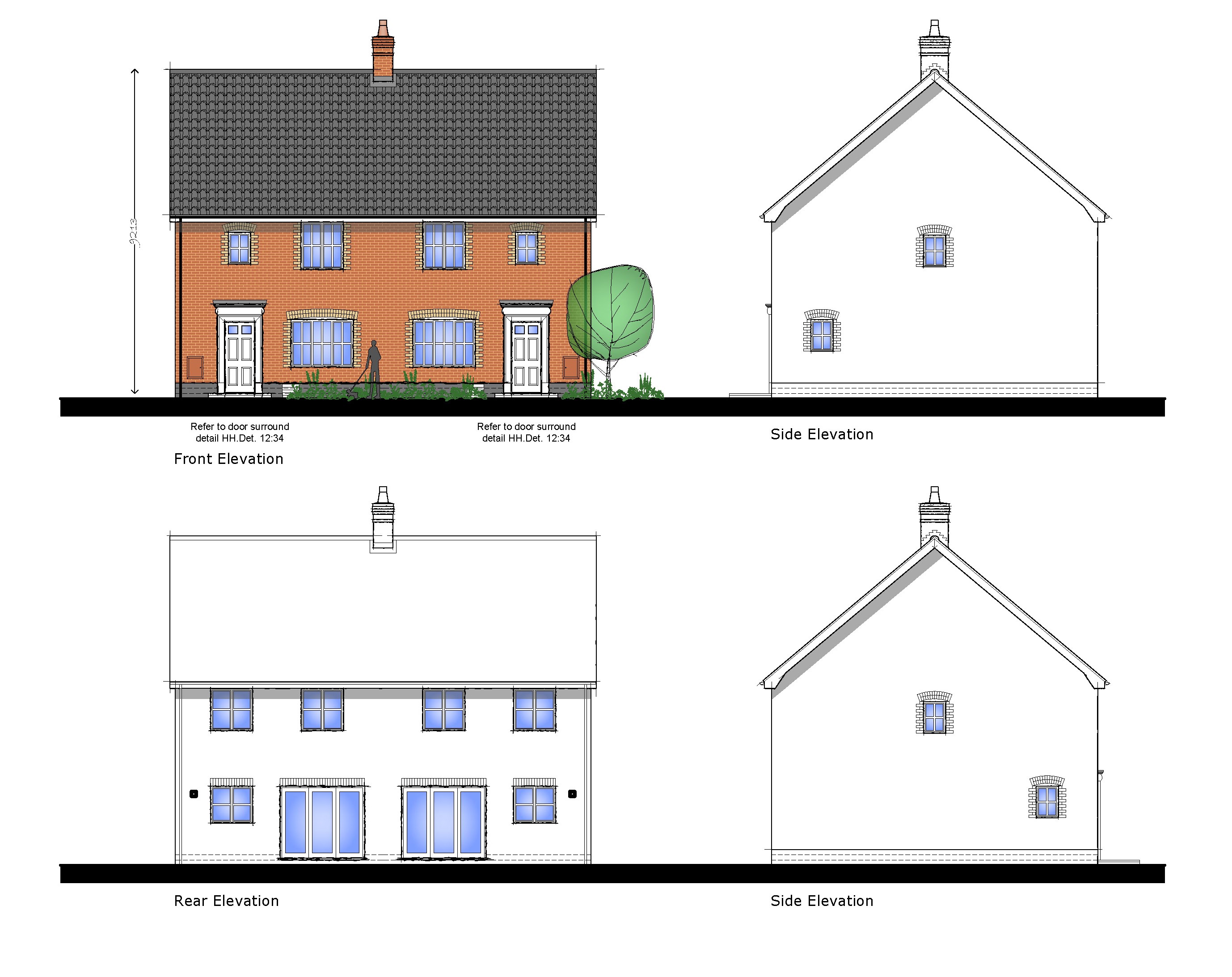
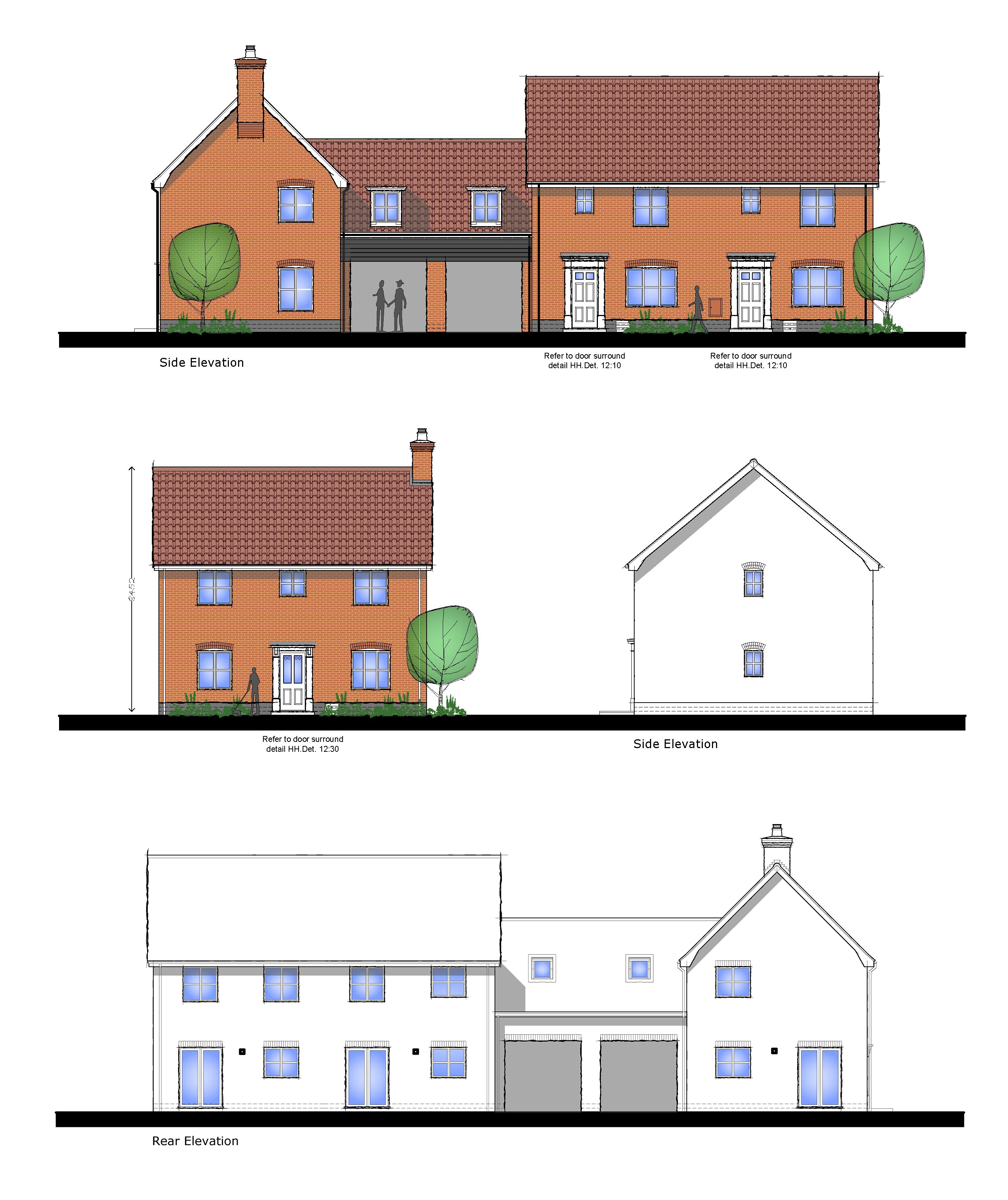
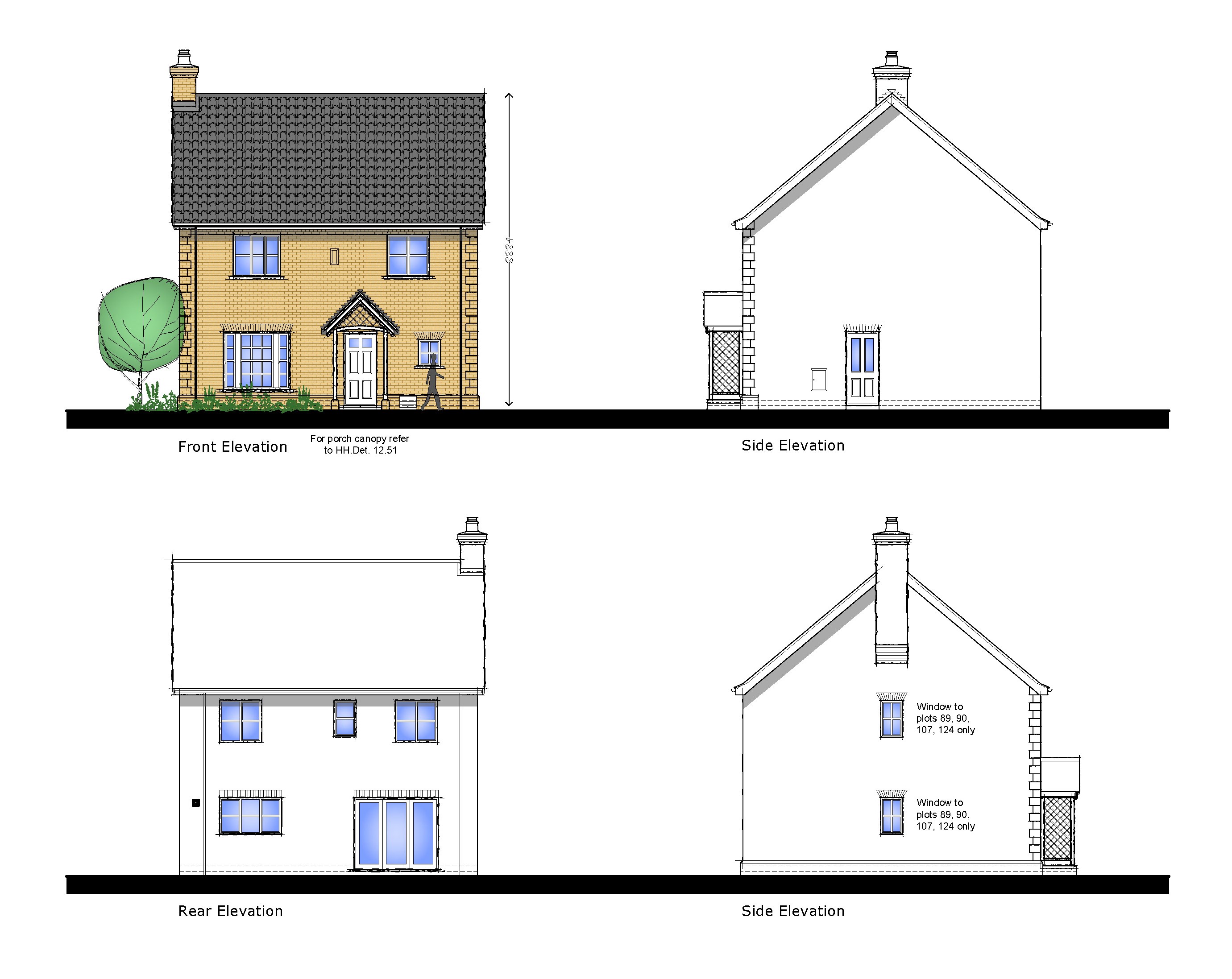
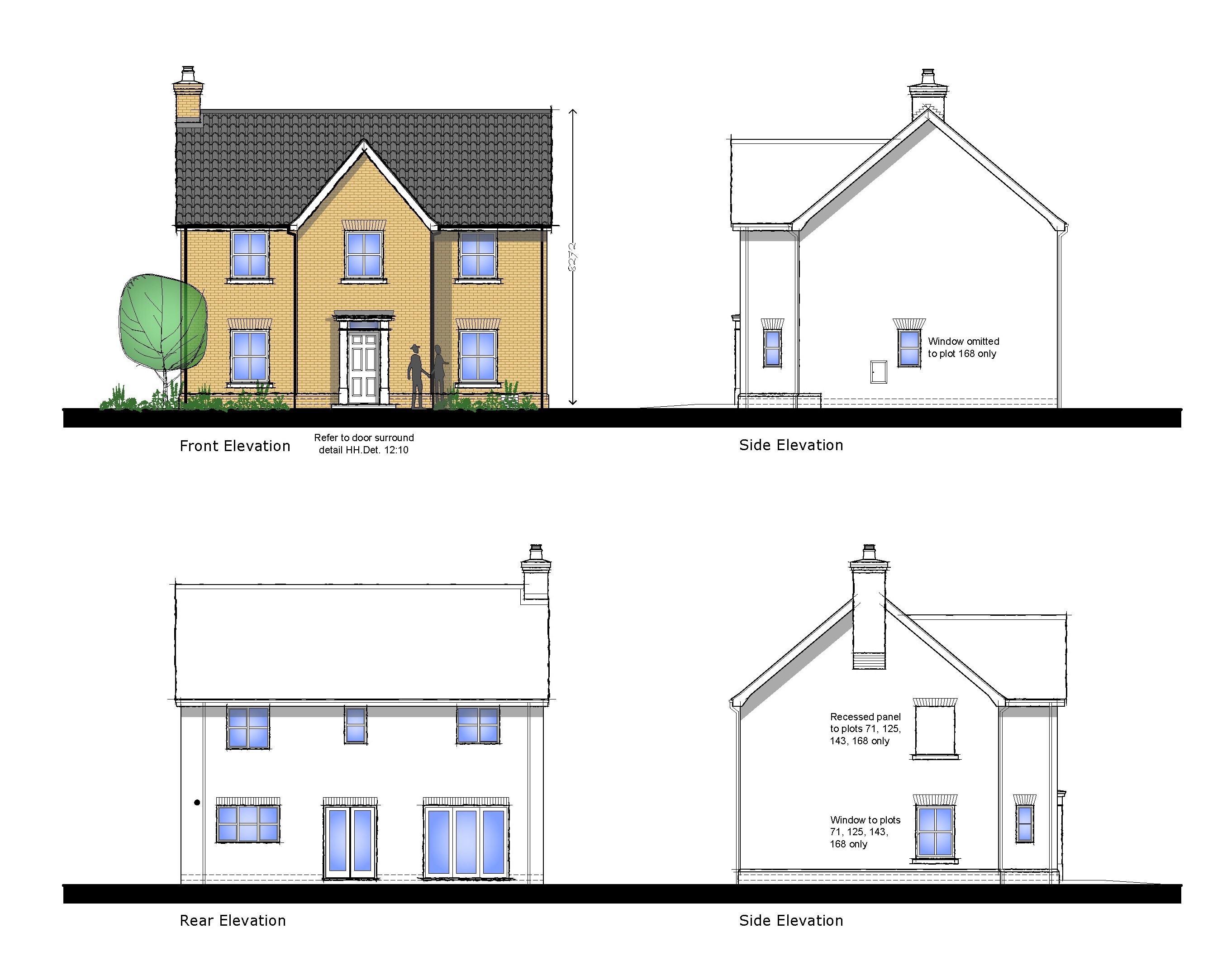
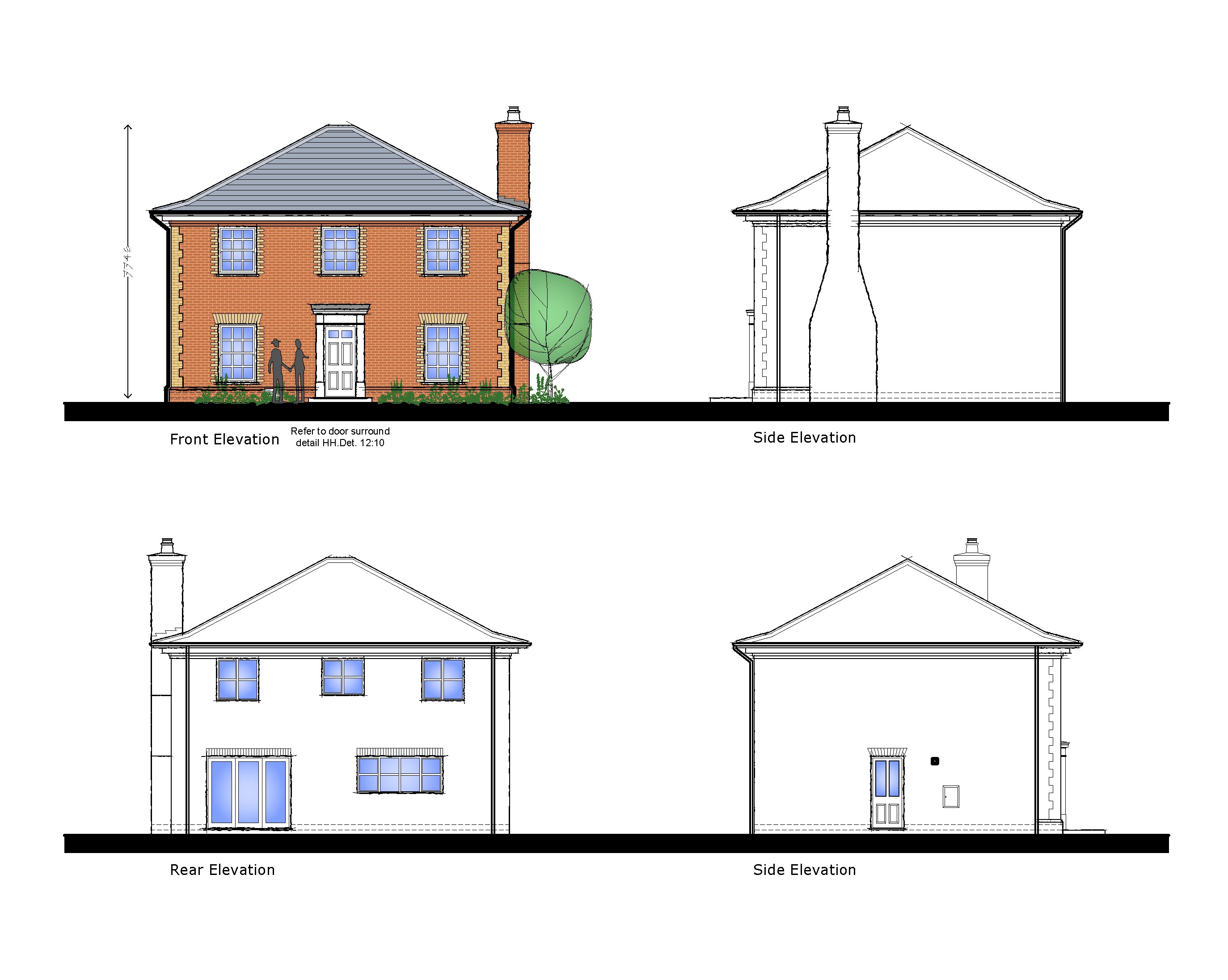
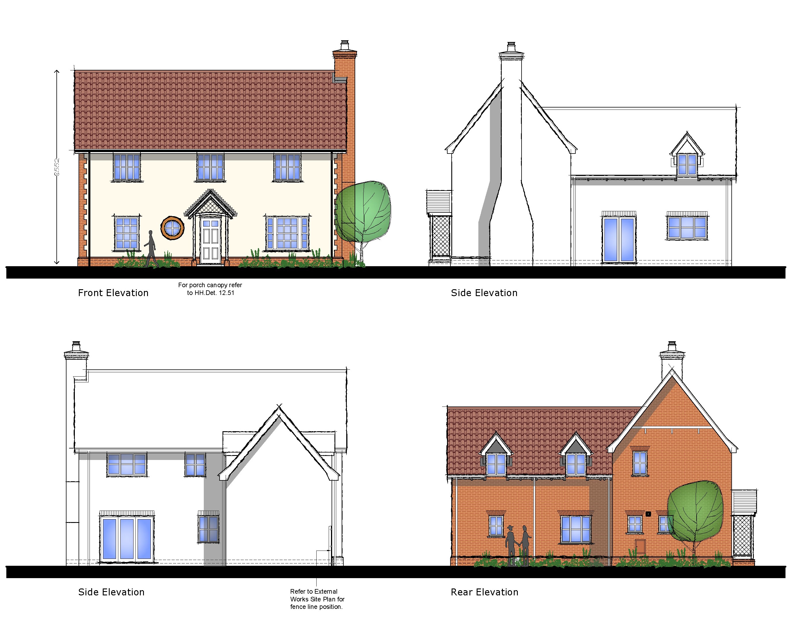
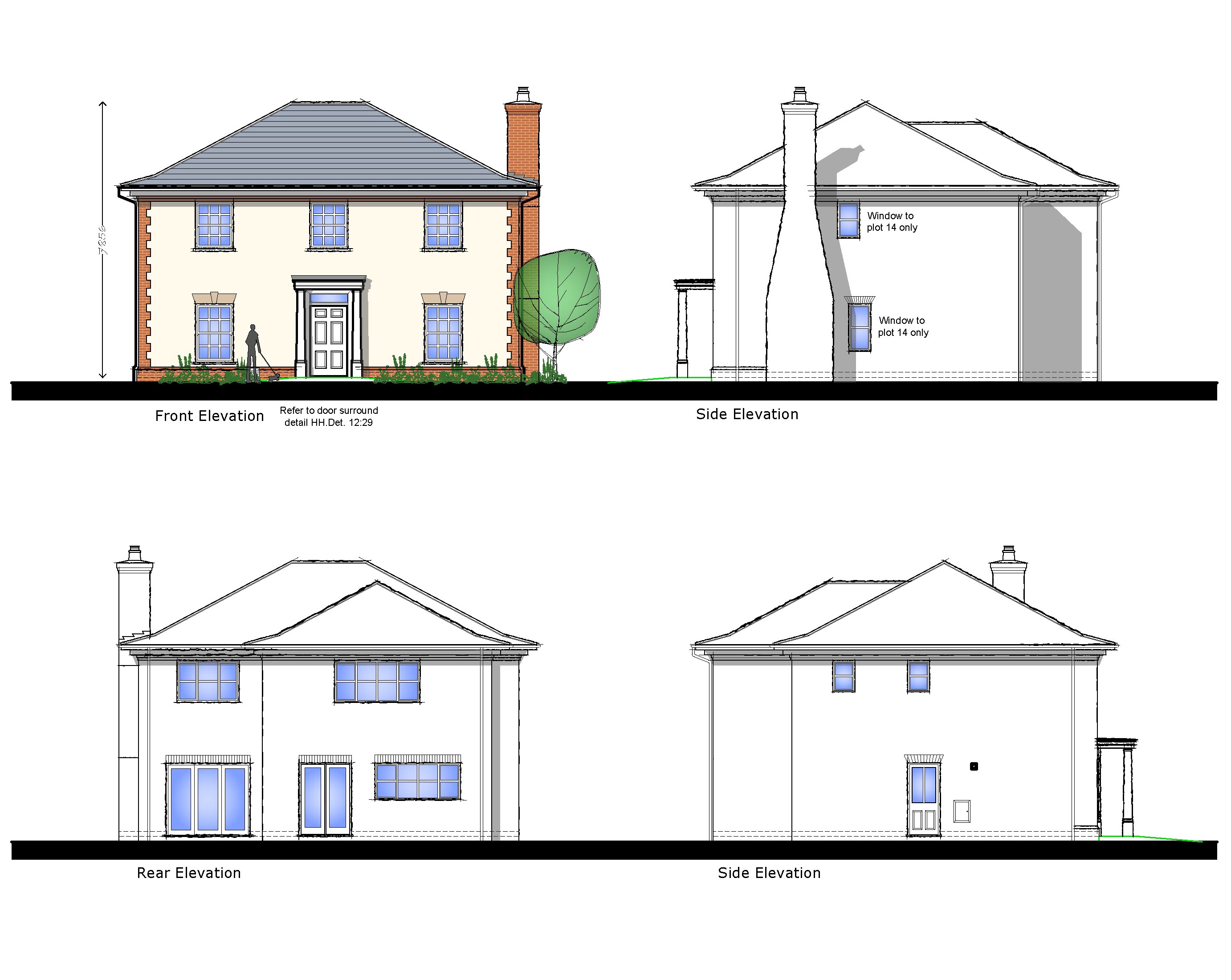
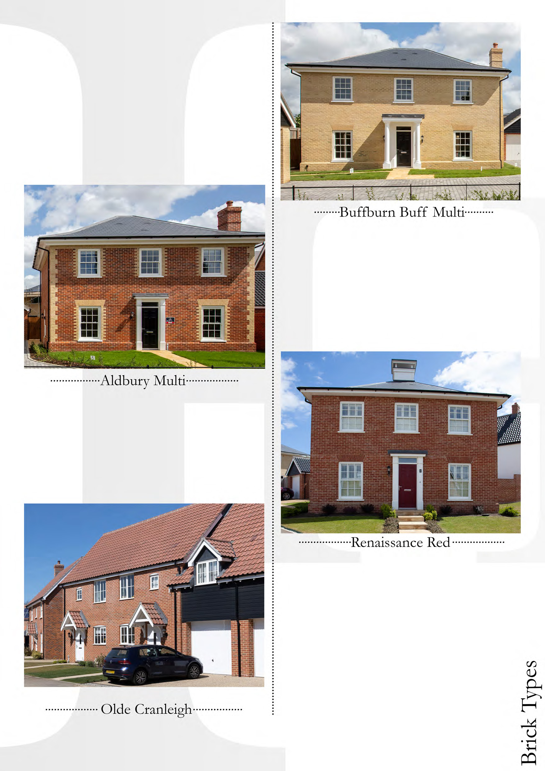
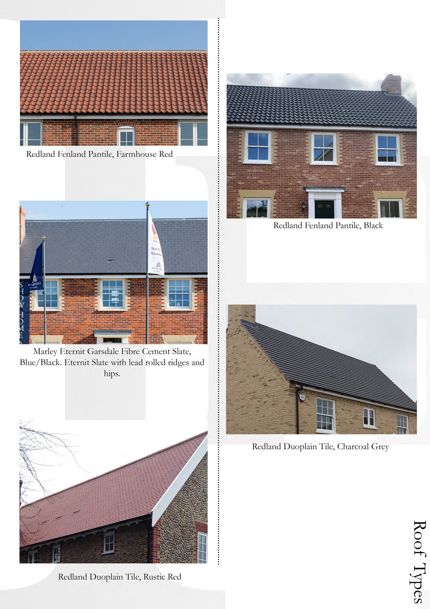
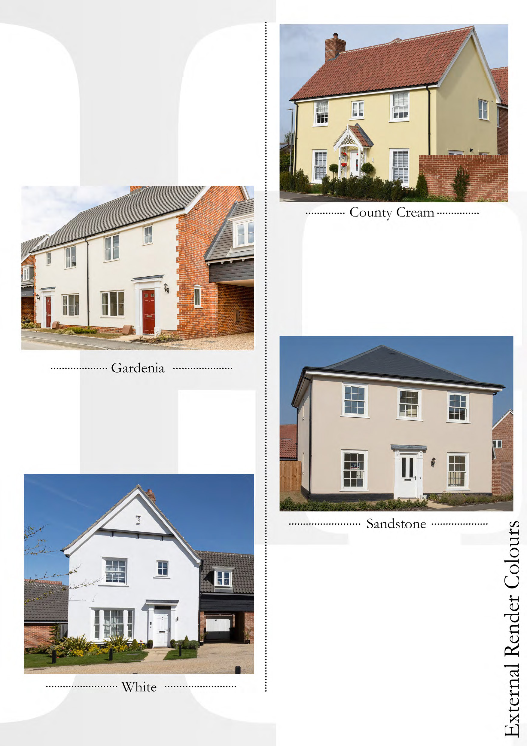
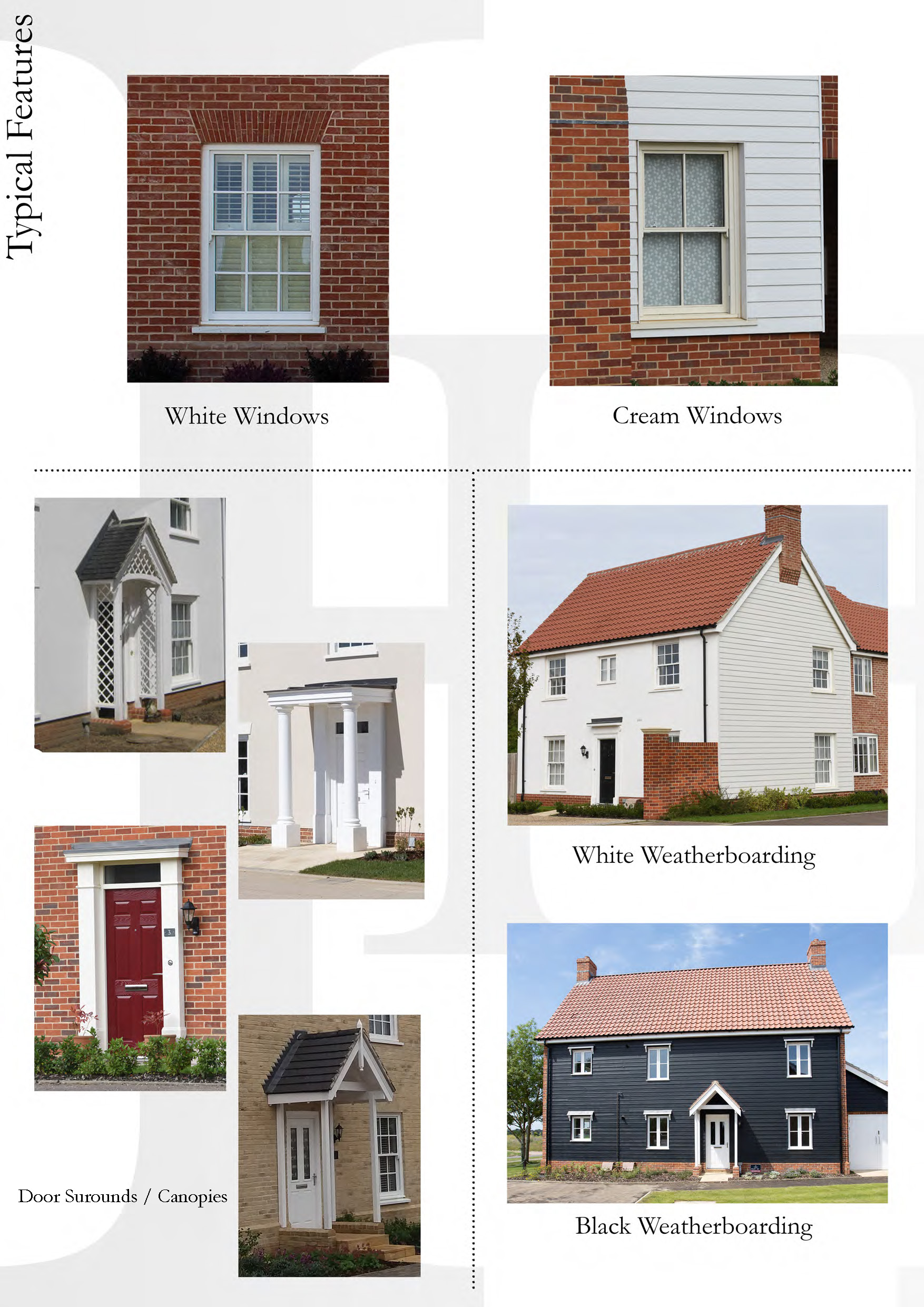
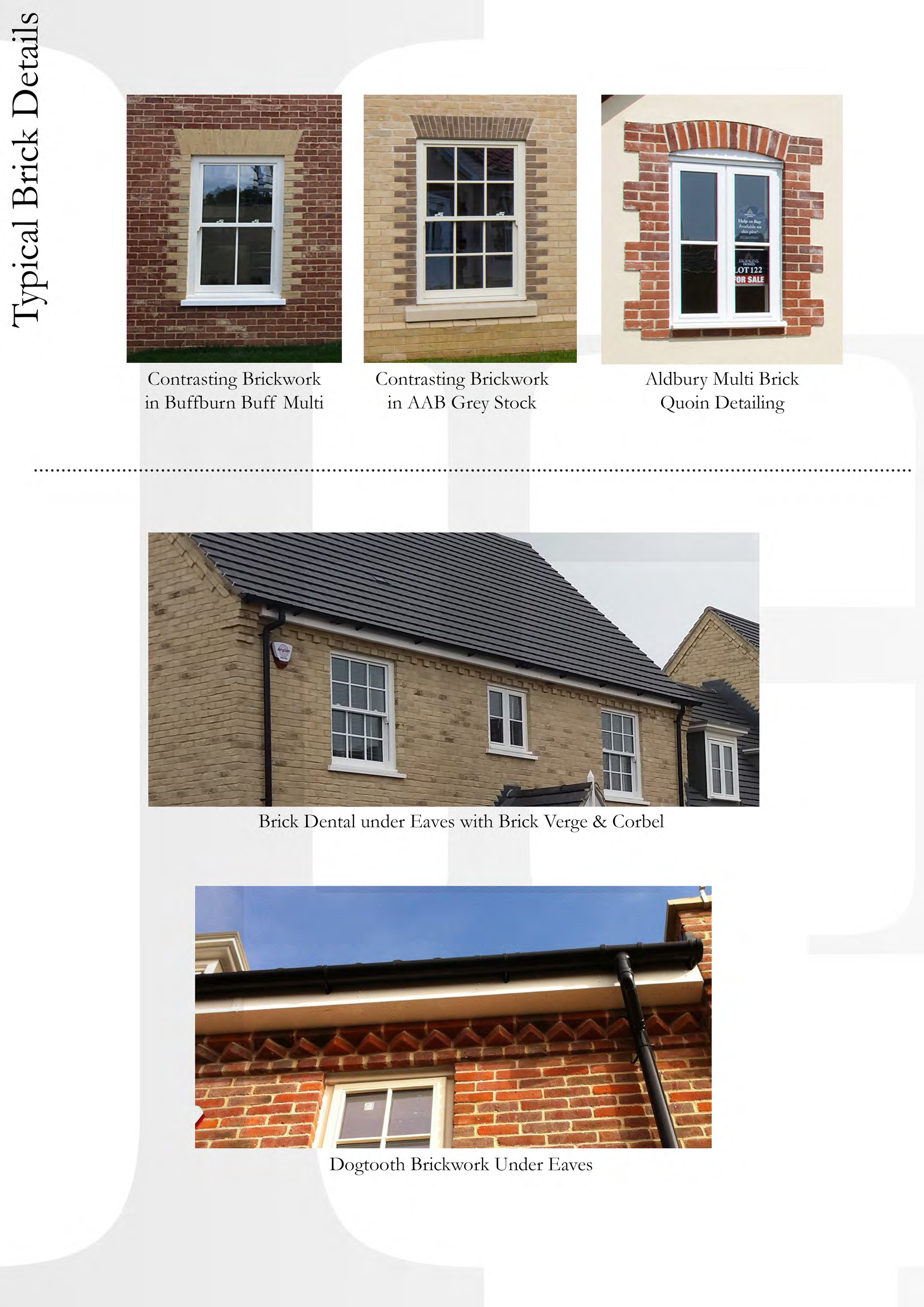
The vision for the design of the development is to create a scheme which relates to its position on the ‘rural edge’ of the town of Loddon. Hopkins Homes have sought to use a palette of materials that is attractive and characterful. The proposed building designs, material choices, and inclusion of detailing aims to make reference to the historic core of Loddon, and to reflect the organic growth and collection of architectural styles present within the town as it has grown over the past centuries. Some precedent examples of the types dwellings that could be delivered, are provided in this section.
The proposed site layout has been carefully planned to provide essential highway safety, to avoid on-street parking and footways and roads being blocked. This has been achieved by providing car and cycle parking in accordance with NCC’s Car Parking Standards for Norfolk 2007:
- 1 bedroom dwellings to have minimum 1.5 parking spaces.
- 2 and 3 bedroom dwellings to have minimum 2 parking spaces.
- 4 and 5 bedroom dwellings to have minimum 3 parking spaces.
Visitor spaces will be added to locations that are most likely to be subject to on-street parking, so essential highway safety is maintained. In addition, cycle parking will be provided, through inclusion of a rear shed or garage for all houses, and at least one space per unit for flats along with adequate spaces for visitors.
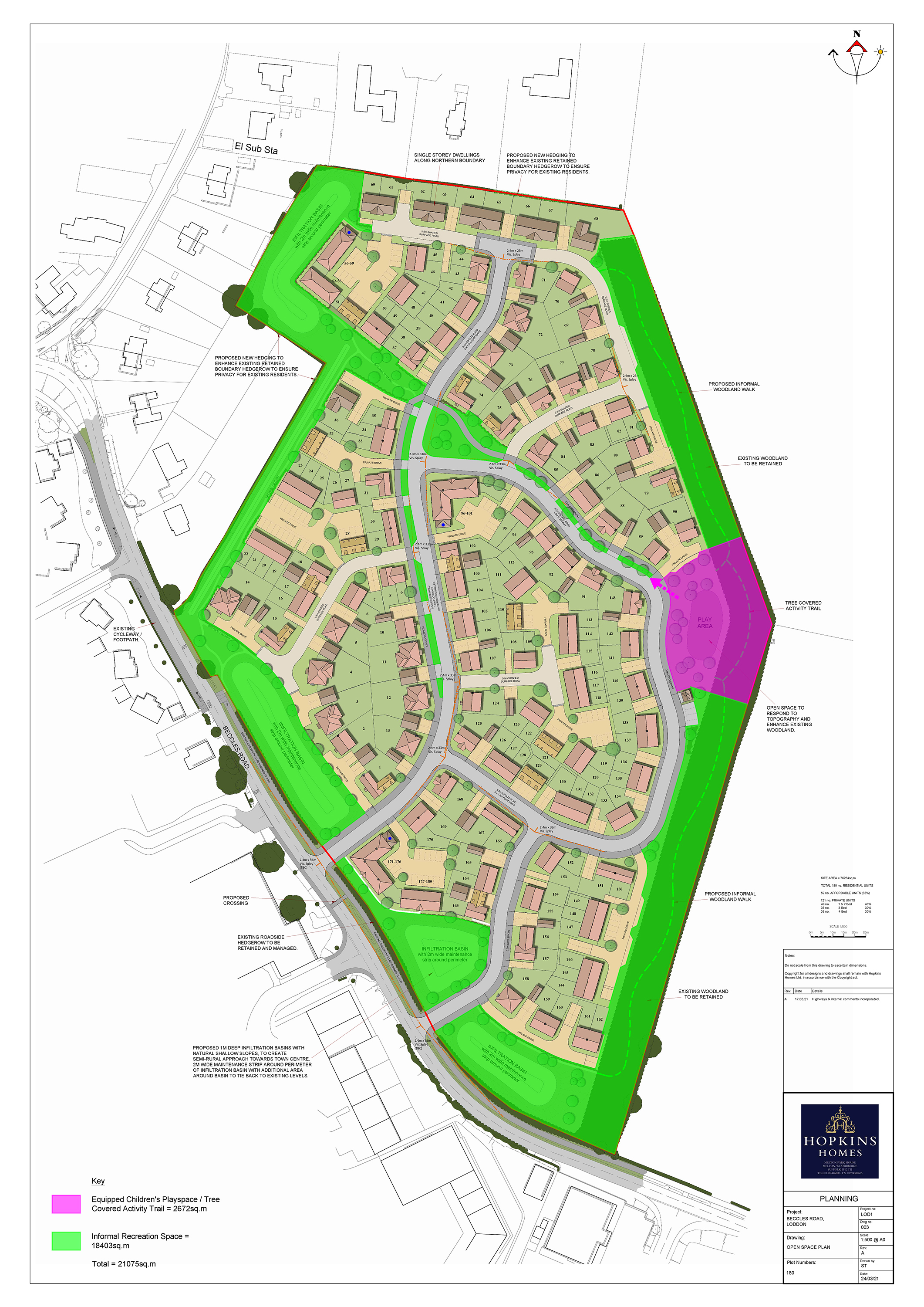
Hopkins are proposing to provide a formal children's play area within the site, adjoined to an interconnected network of informal open spaces that exceed policy requirements. These are shown on the adjacent open space plan.
The proposed dwellings on the northern boundary have been designed as bungalows, and existing boundary hedgerows are to be enhanced to ensure privacy remains for existing residents. Along the western boundaries, the site has been designed with landscaped setbacks and semi-natural drainage features to protect existing residential amenity.
The vision for the design of the development is to create a scheme which relates to its position on the ‘rural edge’ of the town of Loddon. Hopkins Homes have sought to use a palette of materials that is attractive and characterful. The proposed building designs, material choices, and inclusion of detailing aims to make reference to the historic core of Loddon, and to reflect the organic growth and collection of architectural styles present within the town as it has grown over the past centuries. Some precedent examples of the types dwellings that could be delivered, are provided in this section.
The proposed site layout has been carefully planned to provide essential highway safety, to avoid on-street parking and footways and roads being blocked. This has been achieved by providing car and cycle parking in accordance with NCC’s Car Parking Standards for Norfolk 2007:
- 1 bedroom dwellings to have minimum 1.5 parking spaces.
- 2 and 3 bedroom dwellings to have minimum 2 parking spaces.
- 4 and 5 bedroom dwellings to have minimum 3 parking spaces.
Visitor spaces will be added to locations that are most likely to be subject to on-street parking, so essential highway safety is maintained. In addition, cycle parking will be provided, through inclusion of a rear shed or garage for all houses, and at least one space per unit for flats along with adequate spaces for visitors.
Hopkins are proposing to provide a formal children's play area within the site, adjoined to an interconnected network of informal open spaces that exceed policy requirements. These are shown on the adjacent open space plan.
The proposed dwellings on the northern boundary have been designed as bungalows, and existing boundary hedgerows are to be enhanced to ensure privacy remains for existing residents. Along the western boundaries, the site has been designed with landscaped setbacks and semi-natural drainage features to protect existing residential amenity.
This consultation is now closed.
We are not seeking any further comments. Any additional comments submitted may not be considered.
If you seek further information, you can write to us at:
Residential Development Proposals at Beccles Road, Loddon
c/o Lanpro Services, Brettingham House, 98 Pottergate, Norwich, NR2 1EQ
Once a planning application has been submitted, you will be able to formally comment on the proposals by way of South Norfolk District Council’s online planning register or by writing to South Norfolk District Council directly.